Tomorrow (5 August 2023), NASA’s Curiosity rover will notch its 11th year on Mars by doing what it does best: studying the Red Planet’s surface.
The intrepid bot recently investigated a location nicknamed “Jau” that is pockmarked with dozens of impact craters. Scientists have rarely has a close-up view of so many Martian craters in one place. The largest is estimated to be at least as long as a basketball court, although most are much smaller.
Jau is a pit stop on the rover’s journey into the foothills of Mount Sharp, a 5km-tall) mountain that was covered with lakes, rivers, and streams billions of years ago. Each layer of the mountain formed in a different era of Mars’ ancient climate, and the higher Curiosity goes, the more scientists learn about how the landscape changed over time.
Find out how NASA’s Curiosity Mars rover faced the hardest climb of the mission.
Credits: NASA/JPL-Caltech
The path up the mountain over the last several months required the most arduous climb Curiosity has ever made. There have been steeper climbs and riskier terrain, but the mission has never faced the trifecta of challenges posed by this slope: a sharp 23-degree incline, slippery sand, and wheel-size rocks. This trifecta left the rover struggling through a half-dozen drives in May and June, vexing Curiosity’s drivers back on Earth.
“If you’ve ever tried running up a sand dune on a beach – and that’s essentially what we were doing – you know it’s hard, but there were boulders in there as well,” says Amy Hale, a Curiosity rover driver at NASA’s Jet Propulsion Laboratory.

NASA’s Curiosity used its Mastcam to capture this impact crater in a location nicknamed “Jau” on July 25, the 3,899th Martian day, or sol, of the mission. This was one of dozens of impact craters Curiosity stopped by after completing one of its most difficult climbs ever.
Credits: NASA/JPL-Caltech/MSSS
How to drive a rover
Hale is one of 15 “rover planners” who write hundreds of lines of code to command Curiosity’s mobility system and robotic arm each day. (They don’t operate the rover in real time; instructions are sent to Mars the night before, and data comes back to Earth only after the rover has completed the work.) These engineers collaborate with scientists to figure out where to direct the rover, what pictures to take, and which targets to study using the instruments on its 2m robotic arm.
But rover planners are also constantly on the lookout for hazards. They have to write commands to steer around pointy rocks and minimize wear on Curiosity’s battered wheels. Geologists on the team use their field experience here on Earth to help look out for deep sand and unstable rock formations. There’s even a role on the mission to gauge whether a canyon wall could obstruct radio communications with Earth.

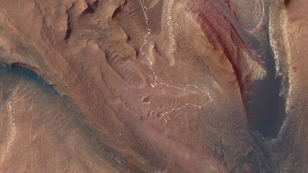
This map shows the route NASA’s Curiosity Mars rover took from May into July to complete the most difficult climb of the mission. Starting in “Marker Band Valley” (the darker area at the top center), the route is shown in white, with dots indicating each stop the rover made.
Credits: NASA/JPL-Caltech/USGS-Flagstaff/University of Arizona
Six-wheeled ascent
Curiosity was never in danger while climbing to Jau: The team doesn’t plan anything that could damage the rover, and the planners write commands so that Curiosity will stop moving if it encounters any surprises. Unexpected stoppages – referred to as “faults” – can occur when the wheels slip too much or a wheel is raised too high by a large rock. On the route to Jau, the rover found itself in both scenarios on several occasions.
“We were basically playing fault bingo,” says Dane Schoelen, Curiosity’s strategic route planning lead at JPL. “Each day when we came in, we’d find out we faulted for one reason or another.”
Instead of continuing to struggle with the original course, Schoelen and his colleagues put together a lateral detour, eyeing a spot roughly 150m away where the incline leveled out. At least, it seemed to: Planners rely on imagery from NASA’s Mars Reconnaissance Orbiter to get a rough sense of the terrain, but images captured from space can’t show exactly how steep a slope is or whether boulders are there.
The detour would add a few weeks to the journey to Jau – unless the terrain was hiding more surprises. If that were the case, the detour might have been for nothing, and the team’s scientists would have to keep looking for another path up Mount Sharp.
Fortunately, the detour paid off, allowing Curiosity to crest the slope.
“It felt great to finally get over the ridge and see that amazing vista,” Schoelen said. “I get to look at images of Mars all day long, so I really get a sense of the landscape. I often feel like I’m standing right there next to Curiosity, looking back at how far it has climbed.”
Since the difficult ascent, Curiosity’s scientists have wrapped an investigation of the Jau crater cluster. Common on Mars, clusters can form when a meteor breaks up in the planet’s atmosphere or when fragments are tossed by a large, more distant meteoroid impact. Scientists want to understand how the relatively soft rocks of the salt-enriched terrain affected the way the craters formed and changed over time.
Despite all that Mars has thrown at Curiosity, the rover isn’t slowing down. It’ll soon be off again to explore a new area higher up on Mount Sharp.
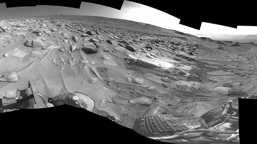
Featured picture: NASA’s Curiosity left several sets of tracks where the rover experienced a fault, or unexpected stoppage mid-drive, while attempting the most difficult climb the mission has faced: a slope with a sharp 23-degree incline, slippery sand, and wheel-size rocks.
Credits: NASA/JPL-Caltech

